
Africa is Splitting in Two: Scientists Uncover a New Tectonic Boundary Forming in Zambia
Africa is on the move — and not in the metaphorical sense. Deep beneath Zambia and the surrounding region, the continent is actively tearing itself apart, with a new tectonic boundary forming as part of the East African Rift System.
This process, known as continental rifting, is one of the most dramatic geological events on Earth. And for the first time, scientists have high-resolution data showing it extending further south into Zambia than previously mapped.
- The Big Picture: The East African Rift System
The East African Rift System (EARS) is a 3,000 km-long zone where the African Plate is splitting into two.
- Nubian Plate: The western block, carrying most of Africa including Zambia, Angola, and West Africa.
- Somali Plate: The eastern block, carrying Ethiopia, Kenya, Tanzania, and the Horn of Africa.
The two plates are pulling apart at roughly 2-7 mm per year. That’s slower than your fingernails grow, but over millions of years it adds up. The result is a chain of rift valleys, active volcanoes, and deep lakes like Lake Tanganyika and Lake Malawi.
For decades, geologists thought the southern end of the rift stopped around northern Tanzania and Malawi. New GPS, seismic, and satellite data now show the rifting stress extending into eastern and southern Zambia.
- Why Zambia is Key
Zambia sits at the southern tip of the active rift front. Two features make it critical:
The Luangwa Rift Valley: A northeast-trending valley running through eastern Zambia. Recent studies show fault lines here are active, with small earthquakes and ground extension consistent with rifting.
The Zambezi Valley: Near the border with Zimbabwe, the valley shows signs of extensional faulting. This is the same process that created the Red Sea and Gulf of Aden millions of years ago.
What’s happening in Zambia is the “propagation” phase of rifting — where the crack in the crust is growing southward, connecting older rift segments in Malawi and Tanzania.
- How We Know It’s Happening Now
Scientists aren’t guessing. The evidence comes from:
- GPS stations: Installed across Zambia and Malawi, these measure ground movement down to millimeter precision. Data show eastern Zambia is moving eastward relative to western Zambia.
- Seismic data: A higher frequency of small, shallow earthquakes along the Luangwa Valley indicates active faulting.
- Geodetic imaging: Satellite InSAR data reveal the ground is slowly stretching and subsiding in rift zones.
This multi-method approach confirms that the rift isn’t fossilized — it’s active.
- What Happens Next
If the rifting continues, the long-term outcome is continental breakup:
- Stage 1 – Active rifting: What we see now in Zambia. Faulting, earthquakes, and valley formation.
- Stage 2 – Seafloor spreading: In 5-20 million years, the crust could thin enough for magma to reach the surface and create new oceanic crust.
- Stage 3 – New ocean basin: Eventually, the Somali Plate would separate completely, creating a new ocean between East Africa and the rest of the continent. The Red Sea is a younger version of this process.
None of this will happen in human timescales. But the processes shaping it are happening right now.
- Why It Matters Beyond Geology
Earthquake hazard: Active rifting means increased seismic risk for eastern Zambia and Malawi. Understanding the fault system helps with building codes and disaster preparedness.
Water and resources: Rift valleys control groundwater flow and can host mineral deposits. Zambia’s copperbelt sits near older rift structures, and new rifting could influence future exploration.
Landscape and ecology: The rift is already shaping rivers, lakes, and ecosystems. As valleys deepen, they create isolated habitats that drive evolution and biodiversity.
Scientific value: Continental breakup is rare to observe directly. Most ancient rifts are buried or eroded. Zambia gives geologists a live laboratory.
- The Broader Context
Africa is the only continent where you can watch a new ocean basin being born from start to finish. The northern end in Ethiopia and Eritrea already has seafloor spreading in the Afar Depression. The southern end in Zambia is the youngest, most active front.
This makes the region one of the most important places on Earth for understanding plate tectonics, the process that built every ocean and mountain range we see today.
- What This Means for Earthquake Risk and Building Standards in Zambia
The fact that rifting is active in eastern Zambia changes the risk profile for the region. It doesn’t mean Lusaka or Copperbelt will see California-style earthquakes tomorrow, but it does mean eastern Zambia should be treated as a low-to-moderate seismic zone, not a zero-risk zone.
Current Seismic Hazard in Zambia
Historically, Zambia has experienced low-level seismicity. The strongest recorded events are:
- 1963 Kariba Earthquake: M6.1, triggered by reservoir loading, felt across Zambia and Zimbabwe.
- Multiple M4-M5 events: Along the Luangwa Valley and border with Malawi in the last 20 years.
These are small compared to East Africa’s rift earthquakes in Kenya and Ethiopia, but they confirm that faults are slipping now.
Why the Risk is Increasing
Rift zones concentrate stress on faults. As the crust stretches:
- Shallow faults become active: Earthquakes in rift zones are typically 5-15 km deep, so shaking is felt more strongly at the surface.
- Faults can link up: Smaller faults connecting over time can produce larger ruptures. The 2009 Karonga earthquakes in northern Malawi, M5.9 and M6.0, were on a southern extension of the same system.
- Induced seismicity: Dams, mining, and water extraction can trigger movement on already stressed faults. Kariba is the classic example.
For eastern provinces like Eastern, Muchinga, and parts of Northern Province, this means the probability of a M5.5-M6.5 earthquake in the next 50 years is higher than previously estimated.
Implications for Building Standards
Zambia’s current building code, SANS 10160, references seismic design, but most rural and peri-urban construction in the rift zone doesn’t account for it. The risk isn’t collapse from a M8 quake — it’s damage from moderate shaking to unreinforced masonry, schools, and clinics.
What needs to change:
- Zoning: Map active faults in the Luangwa and Zambezi valleys. Avoid building critical infrastructure directly on them.
- Design: Require basic seismic reinforcement for schools, hospitals, and government buildings in Chipata, Lundazi, Chama, and border areas. This means reinforced concrete frames, proper foundations, and masonry confinement.
- Retrofitting: Prioritize retrofitting older public buildings. Retrofitting is 3-5x cheaper than rebuilding after a quake.
- Public awareness: Train local engineers and masons on simple earthquake-resistant techniques. Most failures come from poor wall-to-roof connections and weak corners.
What’s Being Done
The Zambia Meteorological Department and Geological Survey have been expanding the seismic network with support from the Africa Array project. More stations mean better hazard maps. The next step is translating that data into updated hazard maps and feeding it into the National Building Code revision.
The Takeaway
Zambia isn’t at risk of a San Andreas-style quake. But the new data show that eastern Zambia should plan for moderate earthquakes the same way it plans for floods and droughts. It’s about low-cost prevention now, rather than high-cost response later.
If you’re building or planning infrastructure in the Luangwa Valley, treat the ground as active. Get a site-specific geotechnical survey and design for M6.5 shaking. It’s a small upfront cost for long-term safety.
Bottom line: Africa isn’t breaking apart overnight. But the data from Zambia confirm that the split is real, active, and progressing southward. For scientists, it’s a rare window into Earth’s engine room. For Zambia, it’s a reminder that even the most stable-looking landscape is dynamic.
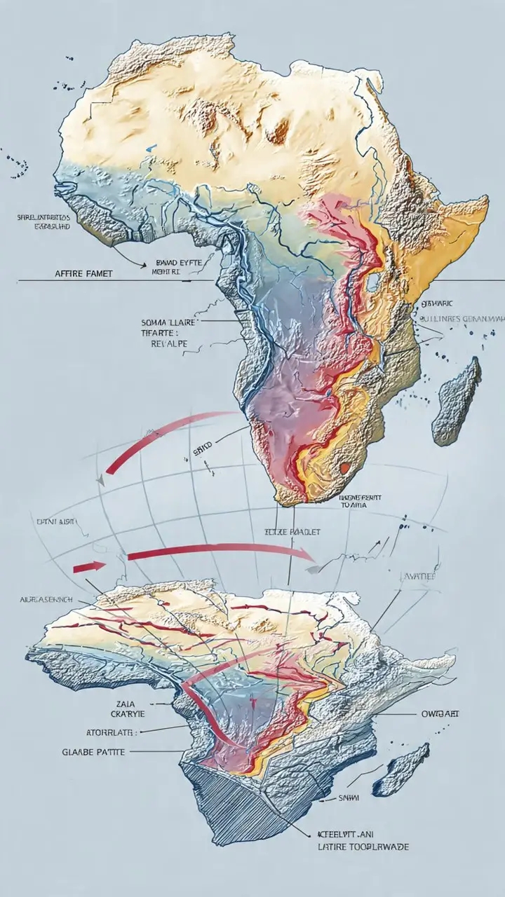
The diagram below shows the current extent of the rift, with Zambia at the southern edge of the active boundary between the Nubian and Somali Plates.